Neighborhoods to Trails
Southwest
Regional Overview
Houston Bike Plan Screenshot of our focus area. Click here for interactive link to the map.

January 2024
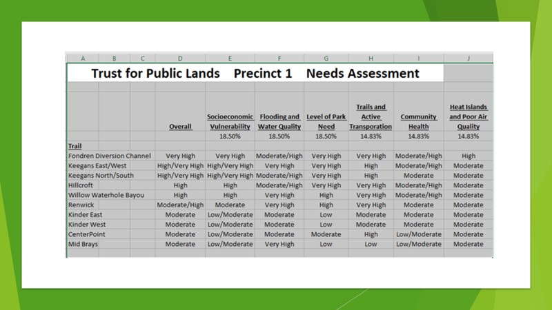
Neighborhoods to Trails Southwest (NTTSW): Status of Core Area Trails and Trails Connecting to Adjacent and Other Important Areas
Updated built, under construction, approved/pending, and proposed trails
- I. Built Trails and Sponsors for NTTSW-Advocated Projects
- a. Brays Oaks Trail segment from Keegans Bayou Trail to Willow Meadow Dr. (COH City Council District J and Harris County Precinct 1)
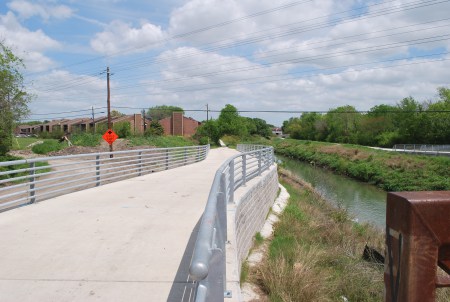
- b. Widening of the sidewalks on the Hillcroft Bridge (City of Houston)
- c. Fondren Diversion Channel Trail extension from Willowbend Blvd. to West Bellfort Ave. (Harris County Precinct 1)
- d. Arthur Storey Park to Archbishop Fiorenza Park (Houston Parks Board, Bayou Greenways)
- e. Widening of the narrow, south side Brays Bayou Greenway Trail section on the bridge section over the Fondren Diversion along South Braeswood (Houston Parks Board)
- II. Trails Currently Under Construction and Sponsors for NTTSW-Advocated Projects
- a. Trails around the several lakes in the Willow Waterhole Greenway (Kinder Foundation, Harris County Precinct 1, and Willow Waterhole Greenspace Conservancy)
- b. Under Highway 59, under Beltway 8, as part of the Brays Bayou Greenway westward expansion project (Houston Parks Board, Bayou Greenways) – Note from HPB: These two areas will be built in 2024 as there are project-related delays
- III. Approved/Pending Trails, Bridges, and Street Crossings and Sponsors for NTTSW-Advocated Projects
- a. Improve Safety of the Bike/Pedestrian Crossing at Endicott Ln. (City of Houston, Houston Parks Board, Harris County Precinct 4)
- b. Remaining section of the Brays Bayou westward extension from Braeburn Glen Blvd. to Archbishop Fiorenza Park (Houston Parks Board, Bayou Greenways 2020 Project extension)
- c. Pedestrian/cyclist bridge over Brays Bayou connecting Braes Blvd. on north side and Linkmeadow Ln. on the south side (Harris County Precinct 1)
- d. New Brays Bayou Trail southside segments going from North Braeswood Blvd. at Greenwillow Dr. across a bridge over the mouth of Willow Waterhole Bayou and extending westward under all of the bridges to Fondren Rd. (Houston Parks Board)
- e. Phase 1 of the Sharpstown Trail from north of Sands Point Dr. to Beechnut St. (Southwest Houston Redevelopment Authority/TIRZ 20 and Houston Parks Board) – Note from HPB: Estimated to start construction in January 2024
- f. Phase 2 of the Sharpstown Trail from Beechnut St. to the Brays Bayou Trail (Southwest Houston Redevelopment Authority/TIRZ 20 and Harris County Precinct 4)
- g. A Brays Bayou Trail segment on the north side to connect to the Atwell Bridge from Chimney Rock to Hillcroft (Houston Parks Board and Harris County Precinct 4)
- h. Replacing Brays Bayou old asphalt trail sections downstream on the south side between MacGregor Park and Hermann Park (Houston Parks Board)
- i. Brays Bayou Trail on the south side from Holcombe to past Buffalo Speedway, under all of the bridges/street crossings (Houston Parks Board)
- j. Plan to eventually replace the asphalt trail from Fondren to Braeburn Glen with a concrete trail (Houston Parks Board and perhaps Harris County Precinct 4)
- IV. Trails and Bridges Having Been Seriously Studied, Under Study, or Ready to Be Studied and Sponsors or Advocates for NTTSW-Advocated Projects
- a. Hillcroft Linear Park and Trail from Willowbend Blvd. south to South Main/Alt 90 (Westbury Civic Club, Westbury Area Improvement Corporation, NTTSW, Harris County Precinct 1, and the Brays Oaks Management District)
- b. Pedestrian/cyclist bridge over South Main/Alt 90 to connect the Willow Waterhole Greenway to the Hiram Clarke area (NTTSW and the Hiram Clarke/Fort Bend Tax Increment Reinvestment Zone/TIRZ 25)
- c. Renwick Trail Feasibility Study from North Braeswood Blvd. to Beechnut St. (NTTSW, Houston Parks Board, Harris County Precincts 4 and 1 and COH City Council District C)
- V. Proposed Trails/Bridges/Upgrades/Amenities and Various Project Advocates
- a. Hillcroft North Trail from North Braeswood Blvd. to Bissonnet St. and possibly Bellaire Blvd. (NTTSW, Braeburn Super Neighborhood Council 30, Gulfton Super Neighborhood Council 27, Harris County Toll Road Authority’s Tollways to Trailways)
- b. Kinder West Trail from West Bellfort at Chimney Rock to Willowbend Blvd. (NTTSW, Willow Waterhole Greenspace Conservancy, Westbury Civic Club/Area Improvement Corp./Super Neighborhood Council 37)
- c. Extension of the Brays Oaks Trail south to West Bellfort (NTTSW, Braeburn Valley West Civic Club, Harris County Precinct 1, COH City Council District J)
- d. Creating a safe street crossing at Fondren Middle School and South Braeswood which will create a proper transition between the Brays Bayou and Fondren Diversion Channel Trails (NTTSW, Harris County Precinct 4?)
- e. Replace the old asphalt portion of the Fondren Diversion Channel Trail with a concrete trail from South Braeswood to Willowbend (NTTSW, Harris County Precinct 4?)
- f. Extension of the Fondren Diversion Channel Trail farther south from West Bellfort (NTTSW, Brays Oaks Management District Livable Centers Study)
- g. Westward extension of the Keegans Bayou Trail (NTTSW, Alief Super Neighborhood Council 25, Harris County Precinct 4, Harris County Toll Road Authority’s Tollways to Trailways)
- h. Under-bridge pedestrian/cyclist crossing where Willow Waterhole Bayou goes under South Post Oak Rd. (NTTSW, Willow Waterhole Greenspace Conservancy, and maybe Harris County Precinct 1)
- i. Bridge over Brays Bayou just east of where Keegans Bayou enters and just west of the Gessner Bridge with that awful crossing connecting the southside trail to the northside trail (Houston Parks Board and NTTSW)
- j. Connection of the Fondren Diversion Channel Trail to the Willow Waterhole Greenway (NTTSW)
- k. Pedestrian bridge over Willow Waterhole Bayou near the Gathering Place for residents north of the bayou who do not want to walk to either Chimney Rock Rd. or the weir across the bayou in order to access the Willow Waterhole Greenway (Willow Waterhole Greenspace Conservancy)
- l. The Western Connector from the Brays Bayou Trail south to the Hiram Clarke Area (NTTSW, Houston Parks Board)
- m. South Chimney Rock Trail from the Chimney Rock Park to the Sims Bayou Trail (Harris County Toll Road Authority’s Tollways to Trailways)
- n. Obtaining signage for areas outside of the Houston Parks Boards purview, especially along the Keegans Bayou Trail (Friends of Keegans with advice from HPB and permitting approval HPARD and HCFCD)

The proposed trails will connect communities and neighborhoods, including parks, schools, community centers, places of worship, and retail to three bayous: Brays, Keegan’s and Willow Waterhole Bayou by creating off-street walking, hiking, and biking trails. These trails will be for recreation and alternate transportation routes throughout the specific region of southwest Houston
Connectivity: Neighborhoods To Trails
The majority of the identified trails for this project run north and south and will connect with the existing east-west Brays and Keegan’s Bayou trails system. The construction of the identified trails in this project will connect numerous residents to Brays and Keegan’s Bayou trail system. This will provide recreation and off-street transportation to numerous destinations in Houston area. The immediate recreational connection to what is considered a highlight of southwest Houston is Willow Waterhole Greenspace.
The Brays Bayou Trail is a continuous trail from southwest Houston to the Houston Ship Channel. It begins on Keegan’s Bayou at South Kirkwood Road near West Bellfort in far southwest Houston and Harris County and ends where Brays Bayou enters the Houston Ship Channel just inside the east 610 Loop. This east-west trail connects residents of southwest Houston to many areas along Brays Bayou, including the Medical Center, Hermann Park, Houston Zoo, Miller Outdoor Theater, Rice University, Macgregor Park, Texas Southern University, University of Houston and Mason Park, to name a few. Residents of southwest Houston will be able to access this trail system from our neighborhoods due to the connectivity we are trying to accomplish.
The Keegan’s Bayou Trail provides 5 miles of bayou trails along a linear park. The trail runs from So. Gessner to Kirkwood along Keegan’s Bayou. The 10-foot wide multi-use path connects to the Brays Bayou Trail. City Council approved a $1.5 million joint project with TxDOT for the five-mile long hike and bike trail along Keegan’s Bayou. When completed, the 10-foot wide reinforced concrete trail will have two bridges, four under crossings, four on street crossings, accessibility ramps, striping, lighting and landscaping. The Keegan’s Bayou Trail runs from S. Kirkwood at W. Bellfort (near Cummins Elementary) east/northeast along Keegan’s Bayou to S. Gessner at S. Braeswood (near Brae-Burn Country club) and connect to Brays Bayou Trail and on to the city’s 316 miles of trails and on-street bike ways.
We anticipate developing almost nine (9) miles of trails along six segments of bayous, tributaries, easements, or boulevards. This will enable neighborhoods in the region to connect to the larger bayou trail systems and the passive recreational / conservation area of Willow Waterhole Greenspace.
Sims Bayou Connection (TBD)
